WeatherWatcher: Winter Storm Warning in effect until 11 AM Wednesday morning
Tuesday, November 29, 2022
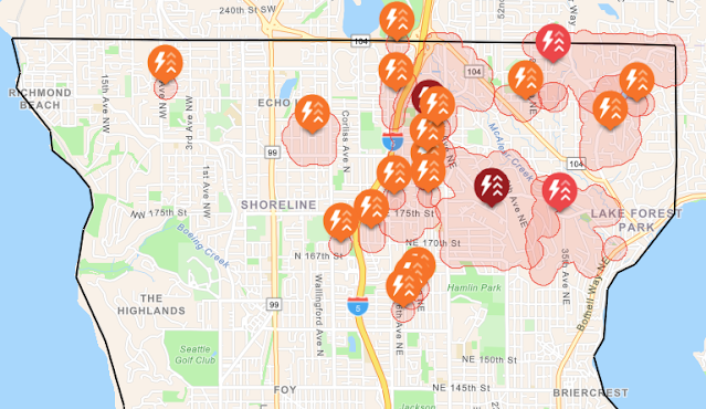 |
| Seattle City Light Outage Map at 10:40 PM PST |
About 3778 City Light customers in Shoreline and Lake Forest Park are without power as of 10:40 PM PST. Shoreline Area News headquarters is now without internet because of the storm. Regular Shoreline Area News will resume once utilities are restored. The Echo Lake / North Ridge weather station is also offline as a result of a power outage.
The National Weather Service in Seattle at 10:24 PM PST has issued a Winter Storm Warning in effect for Seattle and vicinity which includes Shoreline and Lake Forest Park. An additional 3 inches of snow is possible overnight into Wednesday morning. The Winter Storm Warning expires at 11 AM Wednesday.
The Wind Advisory also continues to remain in effect until 7 AM Wednesday morning, gusty winds up to 45 mph are possible. More power outages are likely through the overnight hours into Wednesday morning.
As of 10:40 PM PST the cold front is moving south through Shoreline and Lake Forest Park. Heavy wet snow at times is expected as the cold front moves through. In the wake of the cold front a Puget Sound Convergence zone is expected to develop probably starting around Everett at first and then drifting south through Shoreline.
The Convergence zone will produce mostly snow at these temperatures, locally heavy snow in spots. A warmup to rain or above freezing is still expected tomorrow afternoon but the warmup will be short lived.
Another round of snow showers is possible into Wednesday evening with another inch or so of accumulation expected. Snow accumulations can locally total up to 6 inches by the end of the night Wednesday, even with the warmup in the afternoon.
It's going to be a rough week for winter weather, stay safe out there.
For current weather conditions and real time updates visit www.shorelineweather.com










.jpg)


