 |
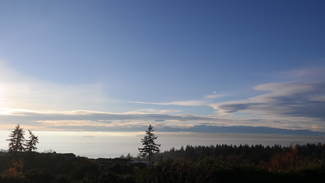
| From a balcony in North City, overlooking the McAleer and Lyon creek watersheds towards Mt. Baker. You can see the shallow layers of fog in the valleys. Photo by Jon Ann Cruver |
A rare break in late November weather gave way to a brilliant sunny day with a mix of patchy fog and high clouds in the area. Clear skies overnight Sunday morning produced some radiative cooling, an effect that often occurs during the longer clear nights between the fall and spring equinox.
Infrared radiation from the surface radiates back out to space, causing the ground to cool down faster than the air above it. With relative humidity levels at near 100% as the ground cooled, a shallow layer of fog formed in lower elevation areas.
We were also between weather systems on Sunday, with our next rainmaker threatening to arrive sometime after midnight Monday morning.
The approach of this storm front produced the high clouds, particularly the lenticular clouds north and east of the Olympic Mountains. You'll notice our sunset was rather red in the photos below, indicating the approaching storm front isn't far off.
Several of our readers sent in photos from across Shoreline from Puget Sound to North City. I'll start with the east side, from the North City neighborhood:
 |
| Sun filtered by fog on top of a ridge in North City. Photo by Cynthia Sheridan |
 |
| Puget Sound and Olympic Mountains with lenticular clouds from Innis Arden. Photo by Jan Hansen |
Finally we'll finish off the day with yet another spectacular sunset at Richmond Beach Saltwater Park. The park was full of visitors, many of them enjoying the view on walks around the park.
 |
| Photo by Lee Lageschulte |
Those red skies I mentioned earlier, demonstrate one of the oldest meteorological rules of forecasting. Red skies at sunset or sunrise indicate an approaching or departing storm front.
The old sailor's saying: "Red sky in the morning, sailors take warning. Red skies at night, sailors delight." In our case though, the red sky is the approaching storm this time, as it will hit overnight, not after sunrise.
For current weather conditions visit www.shorelineweather.com
 |
| Photo by Lee Lageschulte |
Forecast for Monday is a stormy one, as we are expecting a round of rain to arrive overnight, with winds increasing as well. Gusts could get as strong as 40mph in the morning before easing a little in the afternoon to 20-30mph.
Once we get through the storm on Monday though, high pressure rebuilds and clears us up with patchy fog in the mornings, sunny afternoons, and clear and chilly nights. We could see patchy frost in places through the rest of the work week and into next weekend.
Careful on those morning commutes if it takes you out on exposed side streets before sunrise.
For current weather conditions visit www.shorelineweather.com


No comments:
Post a Comment
We encourage the thoughtful sharing of information and ideas. We expect comments to be civil and respectful, with no personal attacks or offensive language. We reserve the right to delete any comment.